
07974 308 637
Drone Inspection Services
We carry out high-level and hard-to-access inspections across a wide range of property types, capturing clear visual data to support condition assessments, maintenance planning, and reporting requirements.
Surveys are designed to identify:
-
Defects and areas of concern
-
Maintenance and repair issues
-
Key points of interest
-
Risks requiring further review
All findings are delivered in a structured format using annotated imagery and clear descriptions to support efficient review and decision-making.
Survey imagery can also be accessed through our interactive viewing platform, featuring:
-
GPS-tagged images on a map overlay
-
Simple navigation between image and location
-
Easy sharing with no software or complicated logins required
-
Clear visual context across larger or more complex sites


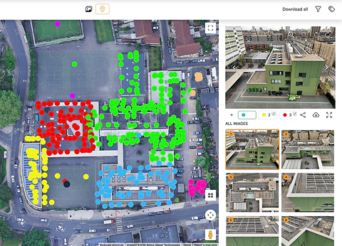
Interactive Viewing – GPS-linked imagery and map-based access through our online survey viewing platform, providing clear visual context of where images were captured.
Designed for simple sharing and easy access, with no complicated logins or software requirements.
High-level inspections that clearly identify defects, risks, and areas of concern across your asset.